Vancouver 2010 Winter Games Related Events at the Irving K. Barber Learning Centre
The Olympics has come and gone, but here is an archive of the programming schedule that the Irving K. Barber Learning Centre had sponsored in 2010.
October Events

Drugs in the Olympics
October 14, 2009, 7:00 – 9:00pm Check back for the video podcast
St. John’s College Olympics Lecture Series: Drugs in the Olympics.
The programming group recorded the St. John’s College Olympics Lecture Series: Drugs in the Olympics by Dr. John Hoberman, University of Texas. Dr. Hoberman is a European cultural and intellectual historian and has done extensive research on sports doping and the intersection of sports, politics, science, public opinion and the Olympics.He has taught courses on sport and politics at Harvard University, the University of Chicago, and The University of Texas at Austin
November Events

The Olympics and Freedom of Speech
November 19, 2009 at 5:30 pm Check back for the video podcast
Chapman Discussion Series Presents: The Olympics and Freedom of Speech Discussion featuring expert panelists and an interactive discussion.
Come and take part in this timely discussion about the Olympics and its effect on our freedom of speech. Expert speakers include:
- Daniel W. Burnett, UBC Graduate School of Journalism professor, media law expert;
- Margot Young, UBC Law, constitutional law expert, and coauthor of Poverty: Human Rights, Social Citizenship and Legal Activism.
- Robert Diab, UBC Law / Capilano University professor and author of Guantanamo north: terrorism and the administration of justice in Canada, nominated for a 2009 Ryga award.
Ian Chan
November 23, 2009 at 6:00 pm
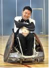
Chapman Discussion Series Presents: Free Film Screening of Murderball with Q&A with Ian Chan and Duncan Campbell.
Come and watch a screening of the film Murderball, which features the intense rivalry of the Canadian and American quad rugby teams between the 2002 World Championships in Sweden and the 2004 Paralympics in Athens. Featured speaker include Ian Chan, an Olympic Wheelchair Rugby player who appears in the film and Duncan Campbell, the “father†of the sport. Both will be available to answer questions in the post-screening Q&A session. For more information, see these reviews of Murderball or this brief backgrounder on Ian Chan and Duncan Campbell.
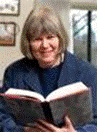
Jean Barman
November 26, 2:00 -3:00 pm
The Robson Reading Series Presents: Jean Barman. Check back for the video podcast.
In 2008, British Columbia celebrated the founding of the Crown Colony of British Columbia and 150 years of cultural diversity, community and achievement. As a celebration of this milestone, Jean Barman’s British Columbia: Spirit of the People captures the rich selection of archival images depicting the province’s past paired with iconic and stunning colour photographs capturing the diversity of the modern landscape.
- When: November 26, 2-3pm
- Where: Lillooet Room 301, Irving K. Barber Learning Centre. Here is a floor plan.
December Events
December 18 – March 1, 2010
Gallery Exhibit on UBC’s Unique Olympic Legacy.
Organized by the Library Olympics programming committee, the exhibit features material from University Archives, Rare Books and Special Collections, Musqueam Indian Band, cIRcle, Public Affairs, UBC Reports, and the Athletic department. Five exhibit cases cover UBC’s Olympic legacy through a look at sport – medaled athletes, athletes turned scholars, sports teams that live on forever, and multicultural sports traditions.
Some highlights include photographs of Quene Yip, a Chinese Canadian athlete; Harry Warren, a Great Trekker and Olympian; an indepth look at Rowing through the years; a look at the movers and shakers behind the scenes such as coach Tom Johnson, director Bob Osborne, and doctor Doug Clement; and photographs of Q’aysca:m, a sporting figure for the Musqueam.
- When: December 18- March 1, 2010
- Where: Gallery, Irving K. Barber Learning Centre. Here is a floor plan.
December 18- March 1, 2010
Gallery Exhibit on UBC’s Unique Olympic Legacy.
Organized by the Library Olympics programming committee, the exhibit features material from University Archives, Rare Books and Special Collections, Musqueam Indian Band, cIRcle, Public Affairs, UBC Reports, and the Athletic department. Five exhibit cases cover UBC’s Olympic legacy through a look at sport – medaled athletes, athletes turned scholars, sports teams that live on forever, and multicultural sports traditions.
Some highlights include photographs of Quene Yip, a Chinese Canadian athlete; Harry Warren, a Great Trekker and Olympian; an indepth look at Rowing through the years; a look at the movers and shakers behind the scenes such as coach Tom Johnson, director Bob Osborne, and doctor Doug Clement; and photographs of Q’aysca:m, a sporting figure for the Musqueam.
- When: December 18 – March 1, 2010
- Where: Gallery, Irving K. Barber Learning Centre. Here is a floor plan.
January Events
January 14, 2010, 2:00 – 3:00 PM, book signing 7:00PMstart.
Robson Reading Series Presents: Ian Ferguson.
Ian Ferguson is an award-winning playwright and humorist whose commentaries have been widely broadcast on radio and television. He is the creator of the live improvised soap operas Die-Nasty and Sin City and is currently writing a sitcom pilot for a major U.S. television network. With his brother Will, he is co-author of the runaway best-seller How to Be a Canadian. As a guidebook, How to Be a Canadian tackles the many humorous complexities and nuances of what it means to be Canadian.
- When: Book reading 2-3pm, Book signing at UBC Bookstore.
- Where: Dodson Room 302, Irving K. Barber Learning Centre. Here is a floor plan.
- Book signing is at 7pm at the UBC Library/Bookstore Robson Square: Ian Ferguson and Mark Leiren-Young
January 21, 2010, 7:00 PM.
The programming group presents: PechaKucha Inspired Olympics Forum.
This event will present the many voices, ideas, and colours of the Olympics and Paralympics in Vancouver by students and staff. Usually pronounced in three syllables like “pe-chak-cha”, a Pecha Kucha is a presentation format in which content can be easily, efficiently and informally shown. Under the format, a presenter shows 20 images for 20 seconds apiece, for a total time of 6 minutes, 40 seconds. Join us for this exciting event. Attendees can enter a draw for free 2010 Games Tickets and vote on their favourite presentation. The winner will receive a prize of $500.
- When: Thursday, January 21, 2010, 7PM start.
- Where: Lillooet Room 301. Here is a floor plan.
Saturday, January 23, 2010, 4PM.
Olympics Games Impact (OGI) Study Researchers at IKBLC.
Rob VanWynsberghe and his research team will present on the International Olympic Committee sponsored Olympic Games Impact (OGI) Study that was developed to objectively measure and assign attribution to the potential effects of the Olympic and Paralympic Games on the host city, region and country, their environment and their citizens. For more information about the study please see http://www.ogi-ubc.ca. The OGI research team will present a short and visually engaging overview, as well as discuss their research approach, and will encourage the audience to share their opinions. Prior to this session, the OGI team will share informational posters outlining their research and preliminary findings in the IKBLC main foyer.
- When: Saturday, January 23, 2010, 4PM start.
- Where: Lillooet Room 301. Here is a floorplan.
Feb 1- Mar 1, 2010
The IKBLC Gallery presents: “Snow, ice and gold” an exhibit curated by the Westcoast Calligraphy Society
- When: Feb 1- Feb 12, 2010
- Where: Gallery, Irving K. Barber Learning Centre. Here is a floor plan